 The sixth chapter of Ian Mortimer’s book, The Time Traveller’s Guide to Medieval England, is entitled: Travelling. It deals with how people traveled in 14th century England, and how much travel they did. In my February posting on the medieval English character, I talked about knowledge being conveyed by pilgrims and others. Although these pilgrims sometimes went to faraway places like Jerusalem, Rome, or Santiago de Compostelo, there was considerable travel by pilgrims within England itself. Their most famous local destination was Canterbury after the martyrdom of Saint Thomas a Becket, but major churches throughout the kingdom had their local saints and reliquaries which drew pilgrims.
The 14th century was obviously a time before modern GPS technology but it was also before the widespread use of maps. This was because maps were few, and those which existed were not very portable. For example, there has been a mappa mundi or map of the world at Hereford Cathedral since the beginning of the 14th century. It is the largest known medieval map in England, and it displays the whole world. England appears on the map, but it is very small and distorted. It would not have been of much use to a traveler even if the map had been portable. Similarly, the use of a compass had not yet been adopted in England or northern Europe in the 14th century, although it was known in the Mediterranean countries.
So, how would you travel about England, say from Aust to Canterbury on pilgrimage? There were two obvious choices. You could go by ship from Aust down the Severn Estuary, through the Bristol Channel, around Cornwall to the English Channel, proceed eastward, then around Kent to a port not too far from Canterbury.
The other choice was overland. As a modern person, you would be able to get on the motorway system at Aust and then use motorways all the way beyond modern London and then by A-roads to Canterbury, but such a route was not available in the 14th century. You would have needed to head eastward, hopefully on horseback, but without a compass and map. You would have had to ask directions to the next town eastward, piecemeal, town by town until you reached Canterbury.
Of the two travel choices, I would like to discuss the overland option first. Depending on the exact route you followed on your journey from Aust to Canterbury, some of your route might have used remnants of the Roman Road which extended from Londinium (or London) to Calleva Atrebatum (or Silchester in Hampshire) and on westward to Aust, then by ferry to Wales, and on to Caerleon. If you followed such a route, it may not have been well maintained, and away from that ancient route, you would likely have been directed along lesser roads, lanes, paths, or even across the countryside itself.
Journeys throughout the kingdom would have been similar experiences. There were about 3 thousand miles of main roads in the 14th century, about 40% of them based on Roman roads. Most of these would have been maintained well enough for the king to travel. The entourage of Edward I was said to average 19 miles per day. A youthful Edward III, riding alone, averaged 55 miles per day on a trip to York. However, other roads, lanes and paths might have been in poor shape by comparison. Travel off the main roads could be very slow.
Major stone bridges were scarce at the beginning of the 14th century, but the medieval city of Exeter had one at the time of my book, Plague of a Green Man, and it plays a role at the end of that story. Throughout the century, the number of stone bridges grew, yet most bridges in England were wooden, and these were in various states of repair. Other options for crossing rivers and streams were provided by ferries and shallow places that were fordable. It is hard for us today to imagine the problems which military leaders must have faced in manoeuvring large forces around the countryside without maps and compasses. They often had to find places where rivers could be forded.
The traveler by land faced tolls on many bridges, as well as for ferries, access to some roads, and passage through city gates. These tolls were often only one or two pence, but they could add up for a merchant traveling from town to town to participate in a market or fair. Citizens of towns with charters were exempt from some tolls, especially where royal charters were issued.
There was a significant risk that road travelers could be robbed by highwaymen. Some protection would be achieved by traveling in groups, such as the pilgrimage to Canterbury portrayed by Geoffrey Chaucer. Also, the Statute of Winchester that I mentioned in my last blog posting in connection with men being armed also provided that the right of way for major roads should be cleared of bordering trees, making it harder for highwaymen to surprise travelers.
Frequently, road travelers who did not walk rode on horseback. Horses ranged widely in price from the largest warhorse worth up to 80 pounds sterling to a packhorse worth as little as five shillings. To be ridden, a horse had to be supplemented with other items such as a saddle and spurs for the rider, not to mention a Saint Christopher medal for good luck.
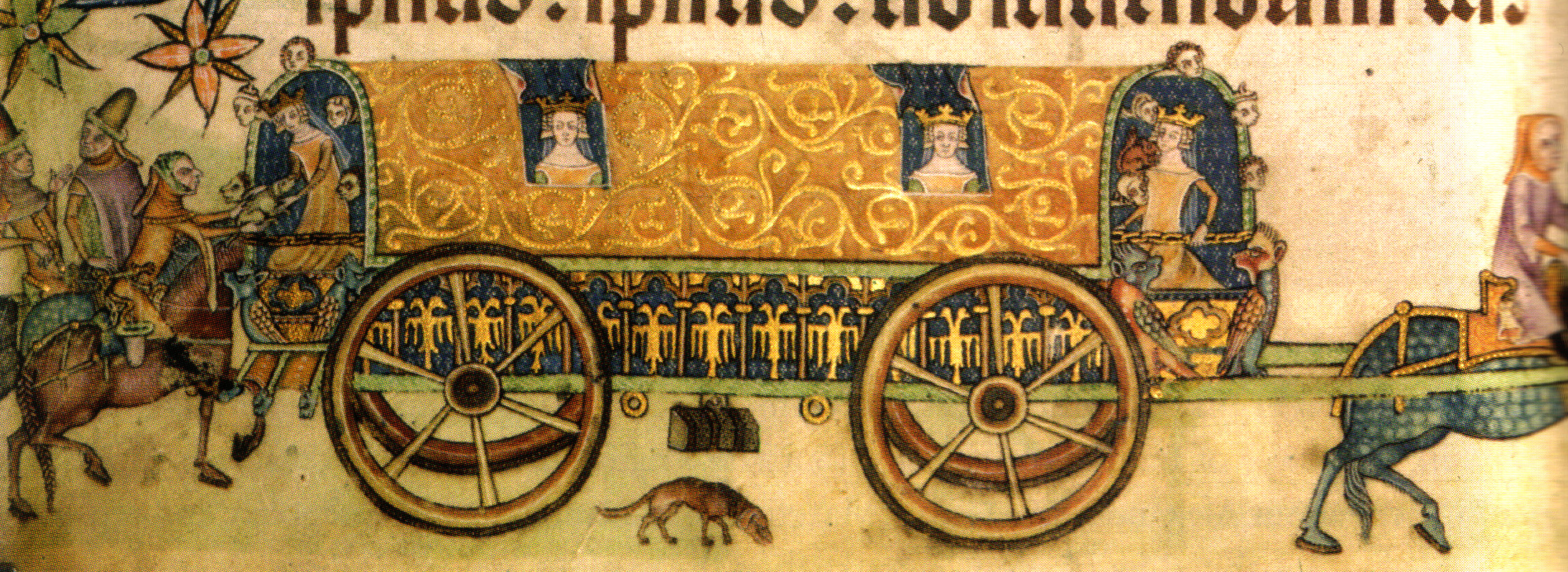
Carts were used to haul things, whereas coaches for people were relatively rare, owned only by royalty or people of high noble rank. I did use one such coach in Memento Mori; it was owned by the Sheriff of Gloucestershire and of the type shown in the picture below.
 The other option for English travel was going by water. Nowhere in England is more than 75 miles from the sea, and most of the population lived much closer than that. By the 14th century, sailors were beginning to venture beyond the sight of land, but most water transport was along the coasts. In Plague of a Green Man, I speak of stone being transported by water from the quarries along the English Channel to the River Exe estuary up to Exeter for the cathedral construction.
Water transport had its problems just like the overland option. Instead of highwaymen, there were pirates and smugglers. Life aboard ships could be very difficult. Weather was often uncertain, but people and goods often used ships in preference to the hazards of overland routes.