Posts Tagged ‘Chaucer’s England’

Medieval Glastonbury History

Tuesday, August 29th, 2017

Glastonbury in 1397 is the setting for Joseph of Arimathea’s Treasure, the fifth novel in my Lady Apollonia West Country Mystery Series.  There are many legends about Glastonbury starting from the Roman period but few written records before the Norman Conquest in 1066.  What records do exist primarily concern Glastonbury Abbey, and many of those were lost in a fire of 1184 or at the time of the Dissolution by King Henry VIII in the 16th century.

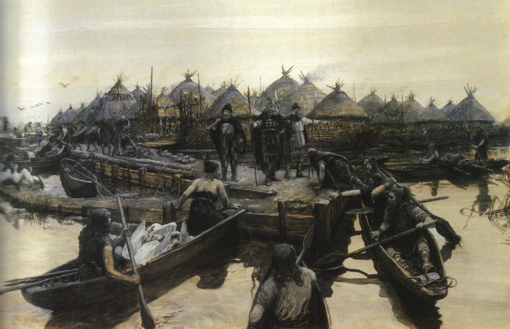
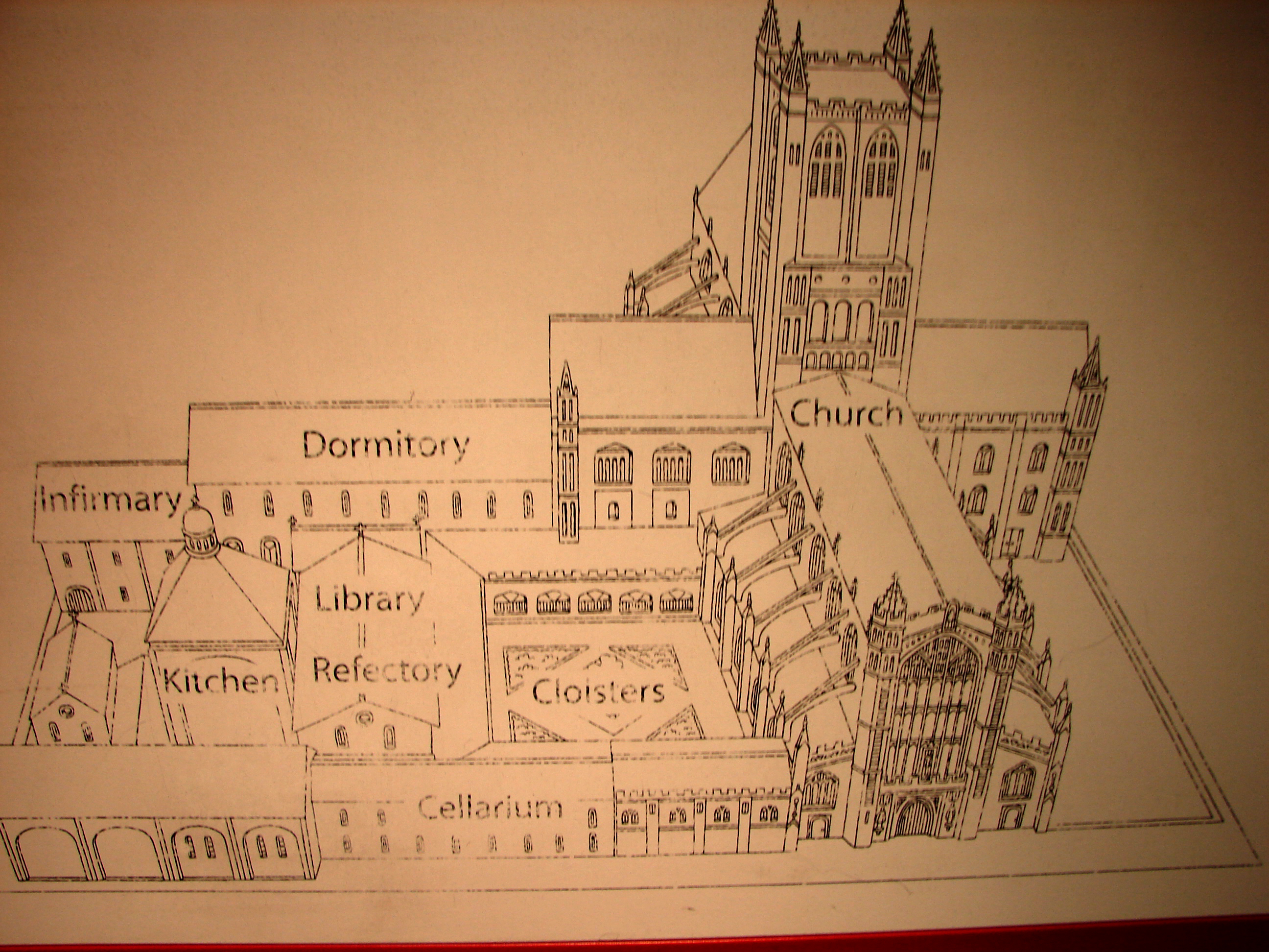
There is written and archaeology evidence concerning Glastonbury Abbey from the seventh century and archaeological evidence concerning Glastonbury Tor, all of which I will discuss in future postings.  After the Conquest, there is much written material about both the abbey and the town.

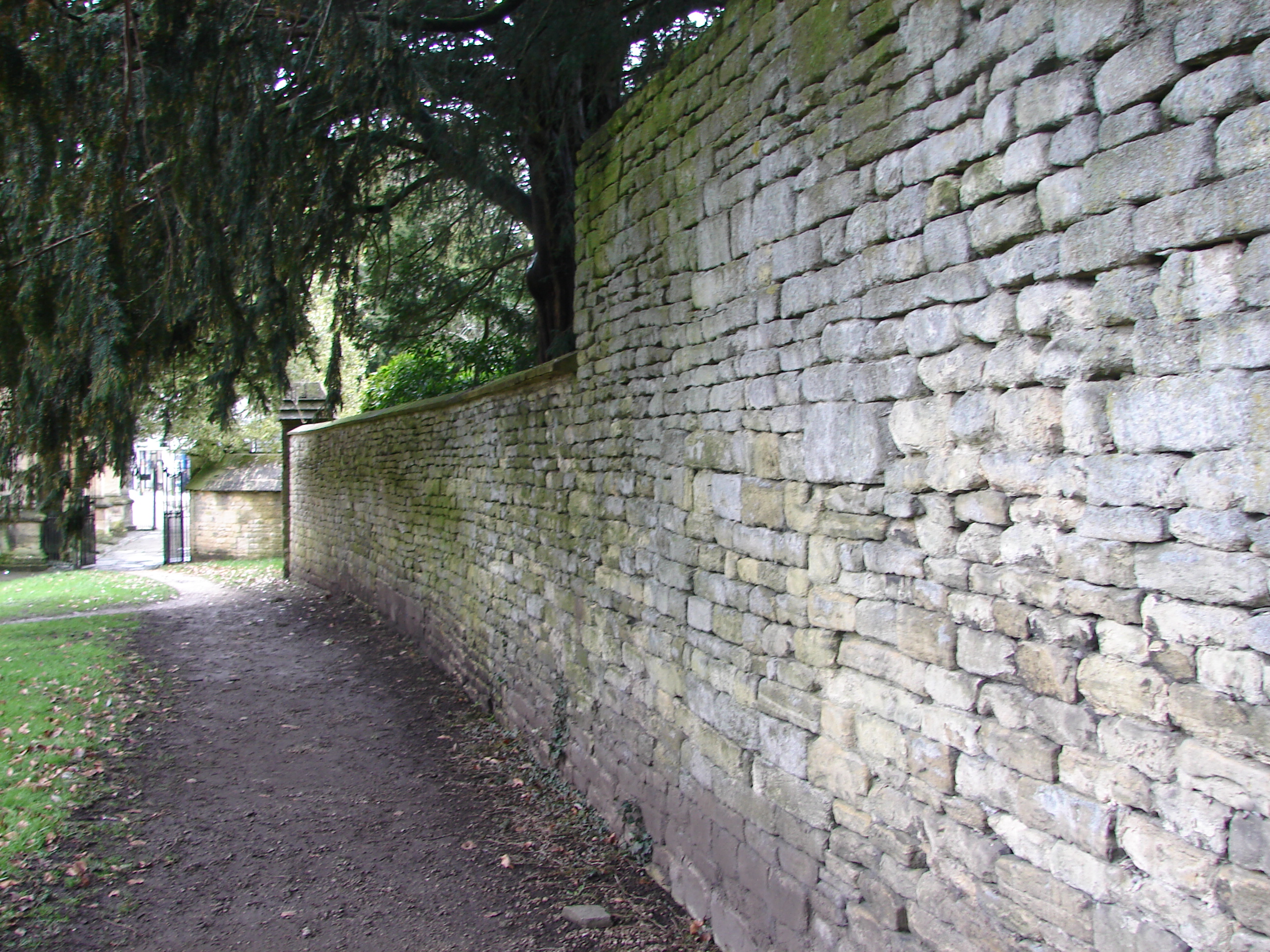
The abbey served as a focal point around which the medieval town grew and towards which the various roads coming into Glastonbury converged.  By the 12th century, the abbey grounds formed almost a square around which the town was developing.  The High street ran along the north side.  On the west was Magdalene Street joining the High Street at the Market Place.  Lambcook Street was on the east side.  The medieval town grew up on these three sides and extended out in the direction of Wells on the northeast, towards the Chalice Well on the southeast, the village Meare to the northwest, and towards Beckery to the west.

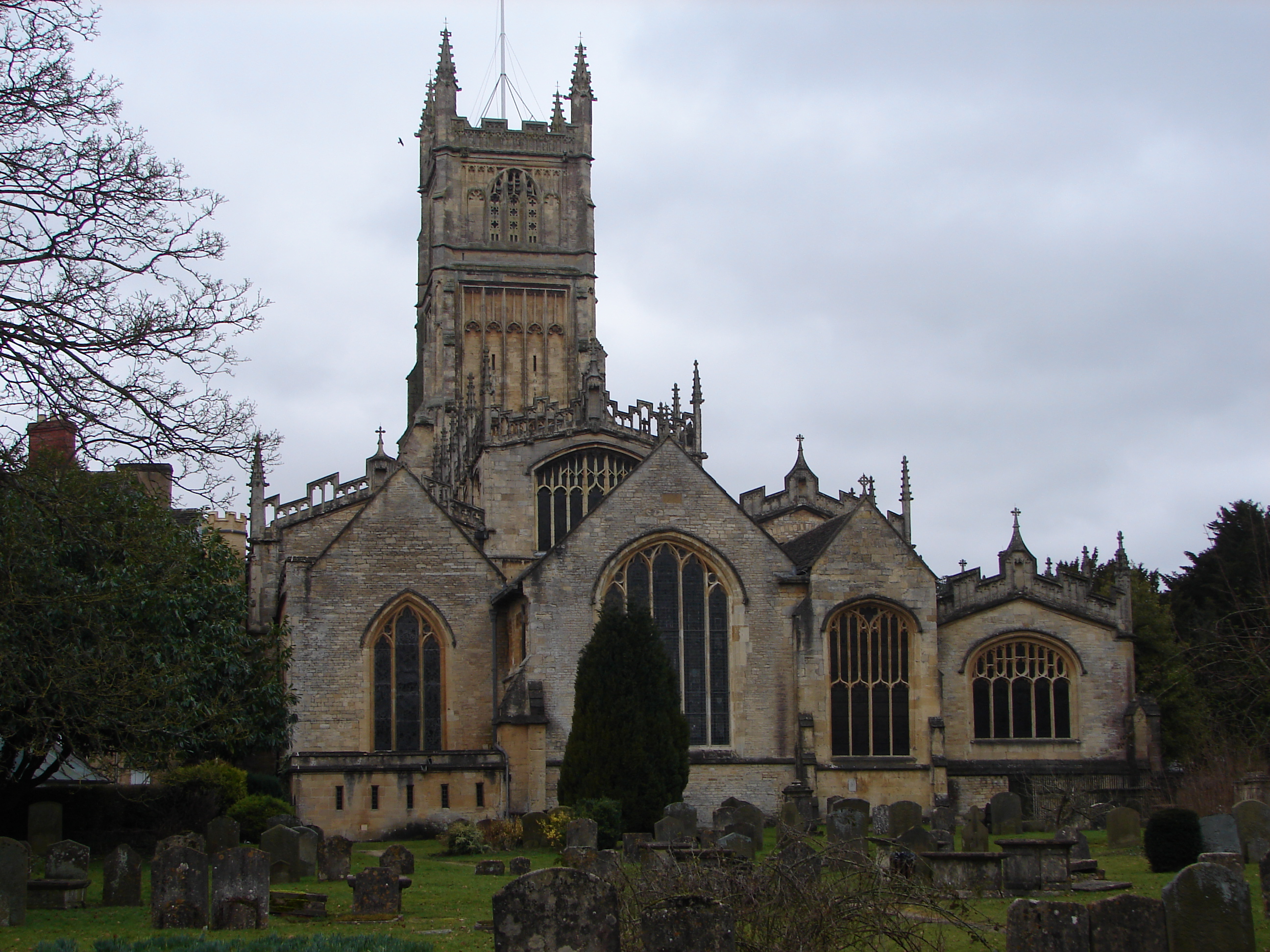
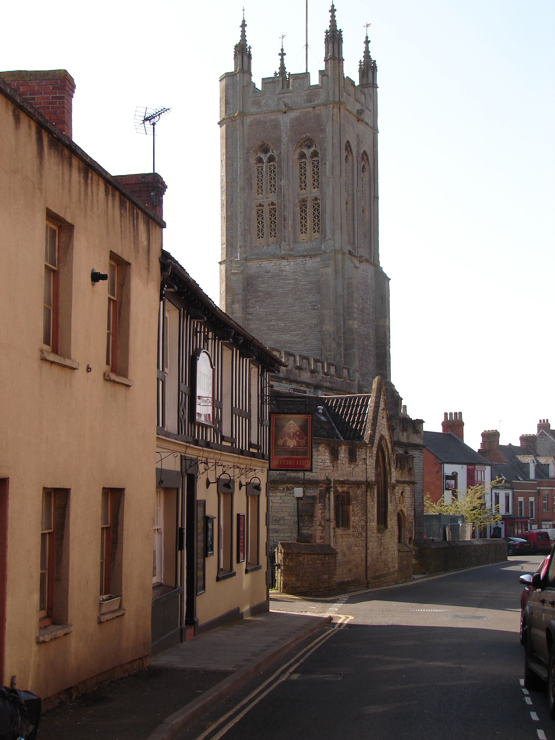
Two parish churches existed at the time of my novel, and both were run by the abbey.  Saint John the Baptist on the High Street was the main parish church as it still is today.  Saint Benignus, due west of the abbey, served as a chapel under Saint John’s church.  In the 17th century, it was renamed Saint Benedict.  The picture above looks down Saint Benedict Street towards the church from the area of the Marker Place.  Today these two churches are joined with Saint Mary’s in the nearby village of Meare to form one modern parish.

From Saxon times, the town catered to the needs of the abbey and was dependent on its fortunes.  In addition to Saint John’s church, there are a couple of buildings today on the High Street that are medieval.  One was a Pilgrim’s Inn to serve pilgrims coming to the abbey.  In the 19th century it became the George Hotel and is now called the George Hotel and Pilgrim’s Inn.  Another is the Tribunal which now houses the Glastonbury Lake Village Museum mentioned in my last post.  Each of these was originally built just after my story, but they give an idea of the architecture of the time.  There are remnants of medieval almshouses just inside the west entrance to the abbey grounds from Magdalene Street and across that street as a part of Saint Margaret’s Hospital.  The abbey tithe barn is just outside the southeast corner of the abbey grounds and now houses the Somerset Rural Life Museum.

Glastonbury History up to Roman Times

Tuesday, August 22nd, 2017

Glastonbury in 1397 is the setting for Joseph of Arimathea’s Treasure, the fifth novel in my Lady Apollonia West Country Mystery Series.  There has been human habitation in the general area of Glastonbury for at least 75,000 years but not in the town itself.  Wooden trackways were built in the Somerset Levels just to the west of Glastonbury from as early as 4000 BC.  The tracks connected areas of higher ground, especially in times of high water due to flooding.

There were also marsh area Celtic settlements called lake villages which were built in the watery environment of the Somerset Levels on great platforms of felled timbers.  One was just at the edge of present-day Glastonbury and another a couple of miles west near the village of Meare.  The picture on the upper left is a 1911 reconstruction drawing by A. Forestier of the Glastonbury Lake Village showing log boats arriving laden with swans.  This village reached its peak of about 200 people in the 2nd century BCE.  Artefacts from the site are on display at the museum located in the Tribunal, a building on the High Street in Glastonbury.

There was trade for British tin from ancient Greece and Rome.  Much of that was Cornish tin, but some of the tin came from the Mendip Hills in Somerset which form the north boundary of the Levels that I discussed I my last post.  The trade in this tin could have been accessed by water just as it was with Cornish tin.

There are many interesting legends about Glastonbury, and I will discuss some of them in future postings including legends that concern Joseph of Arimathea, a New Testament character, coming to Glastonbury.  Since he is part of the title of my novel, I would note here that if he came to Britain as the legends suggest, it would have been when the Celts were settled throughout Britain and before the Roman occupation.  Furthermore, it would have been at a time when Glastonbury was accessible from the sea.

After 43 CE, the Romans treated the area of the Somerset Levels around Glastonbury as a rural area.  However, the Fosse Way, the Roman road which connected Lincoln to Exeter passed just to the east of Glastonbury.  There were Roman settlements in Bath and perhaps the towns of Wells to the northeast of Glastonbury and in Ilchester to the southwest.  There is a cemetery just east of Glastonbury near Shepton Mallet that may contain Roman Christians.

For more on the Glastonbury Lake Village, click on
https://en.wikipedia.org/wiki/Glastonbury_Lake_Village .

For more on the Romans in Somerset, click on
http://www1.somerset.gov.uk/archives/ASH/Romano-brit.htm .

Somerset Levels

Tuesday, August 15th, 2017

Glastonbury in 1397 is the setting for Joseph of Arimathea’s Treasure, the fifth novel in my Lady Apollonia West Country Mystery Series.  Its setting is different from other books in the series in several ways.  First, its location in the middle of the Somerset Levels is an unusual geographic location within the West Country of England.

The Somerset Levels is a coastal plain and wetland in the middle of Somerset.  Glastonbury is a major town centrally located in the region.  From southwest to northeast the Levels are drained largely by the rivers, Parrett, Brue, and Axe.  It is the Brue which flows between Glastonbury and its southern neighbour, the town of Street.

The Bristol Channel has some of the highest tides in the world, and the Levels are nearly at sea-level.  This means that these wetlands have always been subject to flooding from sea water.  Glastonbury is located at the eastern end of a raised peninsula of land which rises hundreds of feet above sea level.  Thus, the hill east of Glastonbury could be seen to rise like an island when people approached the town by boat when the area was flooded.  The peninsula, surrounded on three sides by the Levels, came to known as the Isle of Avalon which I will discuss in a future posting on the connection of King Arthur with Glastonbury.

Since Roman times, men have reclaimed land by drainage from this wetland as was done in the fens of East Anglia and in Holland.  In another future posting, I will discuss the legends about Joseph of Arimathea coming to Glastonbury because these legends say that Joseph lived in this part of England in the early first century before the Romans occupied England and this wetland area.  The Bristol Channel at that time probably extended all the way east to Glastonbury.  Such access from the sea became rarer as land was drained, especially in medieval times.  It was frequently the monasteries such as Glastonbury Abbey that led in this reclamation effort.

Glastonbury is now more than a dozen miles from the sea, so it is hard for us to imagine access to the town from the sea in the west.  Yet, there have been events since medieval times when flooding from the sea again made such access possible.  One was in 1607, well after my 14th century story.  More recently, in 2013 and 2014, the area was subject to flooding from the sea and from massive rainfalls which caused freshwater flooding.  My husband and I experienced some remnants of that flooding on our research trip to Glastonbury in March of 2014.  We had to drive an alternate route from north Devon to get to Glastonbury because the direct highway was still closed from the previous winter’s flooding.  The picture shown above was taken from the heights of Glastonbury Tor in the direction of the River Brue and shows extensive casual water still in the fields, remaining from serious flooding of the Levels in the winter of 2014.

For more on the Somerset Levels, click on
https://en.wikipedia.org/wiki/Somerset_Levels .

Links to buy Templar

Tuesday, August 8th, 2017

For over a month, I have been posting articles on this blog related to Templar’s Prophecy, the fourth novel written in my Lady Apollonia West Country Mystery Series.  This story is set in Cirencester, England, in 1395.  If you have enjoyed reading the posts about medieval Cirencester and have not yet read my story, this might be a good time to order it.


The paperback can be ordered online
from Amazon by clicking
https://www.amazon.com/Templars-Prophecy-Ellen-Foster/dp/1304447731/

or from Barnes and Noble by clicking
http://www.barnesandnoble.com/w/templars-prophecy-ellen-foster/1117494658

or from Lulu Press on sale by clicking
http://www.lulu.com/shop/ellen-foster/templars-prophecy/paperback/product-21290122.html


The ebook can be ordered online
from Amazon on sale for the Kindle by clicking
https://www.amazon.com/Templars-Prophecy-Lady-Apollonia-Mystery-ebook/dp/B00KMU34T2/

or from Barnes and Noble for the Nook by clicking
http://www.barnesandnoble.com/w/templars-prophecy-ellen-foster/1117651332?ean=9781304447760

or from itunes for Apple devices by clicking
https://itunes.apple.com/us/book/templars-prophecy/id763806941?mt=11

or for Kobo devices by clicking
https://www.kobo.com/us/en/ebook/memento-mori-22


Happy reading!

Cirencester Parish Church of St John Baptist

Tuesday, August 1st, 2017

The Cirencester Parish Church of Saint John Baptist is located just south of the abbey grounds and faces the Marketplace to the west.  This is one of the medieval buildings in Cirencester that existed in 1395 when I set Templar’s Prophecy,the fourth novel in the Lady Apollonia West Country Mystery Series.  My heroine lived on Dyer Street and would have passed the church every time she would have walked to the Marketplace or Cirencester Abbey.  She and others in the story had occasion to visit the church itself.

The origins of this church were tied to the foundation of the abbey in the 12th century.  The new abbey was built on the side of a minster church founded in the eighth or ninth century.  It was to replace that church that Saint John Baptist was built as the new parish church.  Enlarged over the centuries, it is now one of the largest parish churches in England as pictured to the top left.

In March of 2013, my husband and I were in Cirencester and visited the church several times including two Sunday mornings when we worshipped there.  It is an impressive church, grandly built because of the money generated by the wool trade in the town.  The aisles on either side of the nave are wide.  The internal length of the church is 158 feet and the width 104 feet.

Today there are several features which have been added after 1395, so one must mentally ignore these to get a feeling for the church at the time of my book.  The impressive tower at the west end of the church was built five years after my story.  The large Trinity Chapel was added to the north wall of the nave in the 15th century as was the multi-storey porch built outside the South door.  The roof of the nave was raised by a height of 20 feet in 1520 at the expense of the town’s merchants.  As one sits in the nave and looks towards the chancel rather than upwards, one sees the church much as it was at the time of my story.

For more on the Church of St John Baptist, click on
https://en.wikipedia.org/wiki/Church_of_St._John_the_Baptist,_Cirencester .

Cirencester Abbey Remnants

Tuesday, July 25th, 2017

The Augustinian Abbey of Saint Mary in Cirencester plays a major role in Templar’s Prophecy, the fourth book in my Lady Apollonia West Country Mystery Series.  The abbey played a major role in Cirencester for over 400 years until the Dissolution of the Monasteries by King Henry VIII in the 16th century and most of it has disappeared as I described in my previous posting.

Still, there are traces of the abbey in and around Cirencester.  The abbey grounds were bordered on two sides by the old Roman wall of which some parts are gone but others are visible.  The Norman arch at the far corner of the grounds from the site of the church was erected as a gatehouse in the 12th century.  Ruins of the Roman wall are visible running next to the River Churn.  Also, the wall that separated the abbey church from the nearby parish church and its churchyard is still standing.  The picture at the top shows a portion of the abbey wall as viewed from the churchyard of the parish church.

A sign along Dollar Street in Cirencester marks the medieval gatehouse or Dole Hall where alms were distributed by the monastery.  The street name, Dollar Street, a corruption of dole, is derived from this activity.  Just outside the abbey grounds are a few arches from the 12th century Saint John’s Hospital which the abbey acquired in the 13th century.  Also, on the edge of town are a dovecote and the barn of Barton Grange which the abbey owned and used.

The Corinium Museum has surviving artefacts from the abbey and displays which give the visitor a view of abbey life in the fourteenth century.  Artefacts from the abbey include carvings of monks and popes, medieval tiles, and pieces of stone fan vaulting.

The abbey also had responsibility for Saint John Baptist, the parish church of which the abbot was the rector.  I will talk more about that church in my next posting.  Shortly after the time of my story, the abbey built the south porch of the church and used the second storey of the porch as a town hall because they controlled the market.  Their newly built town hall overlooked the Marketplace.

For more information on Cirencester Abbey, click on
https://en.wikipedia.org/wiki/Cirencester_Abbey or on
http://www.british-history.ac.uk/vch/glos/vol2/pp79-84

Cirencester Abbey Vanished Buildings

Tuesday, July 18th, 2017

The Augustinian Abbey of Saint Mary in Cirencester plays a major role in Templar’s Prophecy, the fourth book in my Lady Apollonia West Country Mystery Series.  Indeed, the abbey played a major role in Cirencester for over 400 years until the Dissolution of the Monasteries by King Henry VIII in the 16th century.  The monastery, as it appears in my story set in 1395, was built in the 12th century, included the church and cloister, dormitory, refectory, kitchen, infirmary, cellarium, and library.

None of these buildings exists today.  The monastic grounds are a great open expanse of grass forming a town park.  There are flat stones which outline where the abbey church was located as shown in the picture above.  A block of flats, also shown in the picture above, now sits to the northwest of where the church was located, but most of the area where monastic buildings once stood is now parkland.

Today a bandstand and small children’s playground are in the parkland which also features a couple of small brooks and the abbey fishpond.  The flowing brooks are a reminder that the abbey once controlled the milling in town. 

Tension between the abbey and the town was so severe that the townspeople welcomed the Dissolution of the Monasteries in 1539.  Demolition of the abbey church began immediately, and townspeople eagerly used the stone monastic buildings as a quarry.  Some of the stones that were reused can be seen in present-day buildings of the town.

For more information on Cirencester Abbey, click on
https://en.wikipedia.org/wiki/Cirencester_Abbey or on
http://www.british-history.ac.uk/vch/glos/vol2/pp79-84

Cirencester Abbey Life

Tuesday, July 11th, 2017

The Augustinian Abbey of Saint Mary in Cirencester plays a major role in Templar’s Prophecy, the fourth book in my Lady Apollonia West Country Mystery Series.  Indeed, the abbey played a major role in Cirencester for over 400 years until the Dissolution of the Monasteries by King Henry VIII in the 16th century.

The monastery, as it appears in my story set in 1395, was originally built in the 12th century and included the church and cloister, dormitory, refectory, kitchen, infirmary, cellarium, library, muniment room for storing robes, an inn for poor travellers and pilgrims, and the abbot’s house.  The major buildings are shown in the drawing above, which comes from the Corinium Museum in Cirencester.  The abbey church was originally built in the Norman style but was largely rebuilt in the 14th century in the Gothic style and included an ambulatory being added around the quire.

The monastery was a community within a town.  Abbey grounds were surrounded by walls which had gates.  The monks slept in the dormitory, ate in the refectory, held meetings in the chapter house, and went into the church to pray and worship, all buildings within steps of each other facilitated by the cloister which connected them.

The Rule of Augustine was based on charity, poverty, obedience, detachment from the world, the apportionment of labour, the mutual duties of superiors and inferiors, fraternal charity, prayer in common, fasting and abstinence proportionate to the strength of the individual, care of the sick, silence, and reading during meals.  The physical layout of the monastery and its buildings were designed to facilitate the monks’ lifestyle based on the Rule.

Between twenty and forty monks, as well as lay-servants and lay-brothers, with the abbot in charge made up the population of the abbey.  Frequently the abbot was called away to the royal court, and this was the case at the time of my novel.  About that time, the Abbot of Cirencester was upgraded to being a mitred abbot which put him on a par with bishops.  His deputy who was in charge in the abbot’s absence was the prior, and my fictitious prior is a main character in my novel.

Individual monks oversaw various functions of abbey life.  The infirmarer oversaw the infirmary, the abbey’s version of a hospital or sick bay.  The cellarer was the monk in charge of provisions.  Keys are often associated with a cellarer because he needed access to the various storage facilities in the monastery as well as farms owned by the abbey.  The kitchener worked under the cellarer and managed the kitchen.  A chamberlain looked after day-to-day essentials of the monks.

Cirencester Abbey History

Tuesday, July 4th, 2017

The Augustinian Abbey of Saint Mary in Cirencester plays a major role in Templar’s Prophecy, the fourth book in my Lady Apollonia West Country Mystery Series, set in 1395.  Historically the abbey played a major role in the town of Cirencester for over 400 years until the Dissolution of the Monasteries by King Henry VIII in the 16th century.  Cirencester Abbey was founded by King Henry I in the early 12th century and became the largest and wealthiest of the Augustinian abbeys in England.

The abbey church replaced a minster church which had been founded in the 9th or 10th centuries.  The new abbey church and monastery were started in 1117.  Serlo was named abbot and the Augustinian monks took possession in 1131.  The church building was not finished until 1176 when it was consecrated.

Under King Henry II, the manor or feudal lordship of Cirencester was transferred from the Crown to the abbey in 1189.  This gave the abbot considerable power over his manorial tenants in the town.  All townspeople had to do three days’ work a year in making the abbot’s hay and harvesting his grain.  Some tenants had to work a day a week on the abbot’s lands.  Others had to work specific periods on the abbey farms.  Tenants’ own grain had to be ground in the abbot’s mills which meant that the abbey and their millers benefited financially.

The abbot controlled the town market and owned considerable property around the marketplace.  Tenants could only buy and sell at the weekly markets provided they paid a tax to the abbot.  The abbey also controlled the parish church of which the abbot was rector.  Tenants found that they continually owed money to the abbot in matters of inheritance, death, and marriage.

In opposition to the extraordinary abbey control, the citizens or burgesses of Cirencester claimed that they had certain rights dating back to a royal charter they had been granted in 1133.  Every time they challenged the power of the abbey over town matters, the king ruled in favour of the abbey because the abbey declared that the town’s charter was a forgery. 

This constant frustration on the part of the burgesses went on for centuries, well beyond 1395 when my novel was set, so the domination of the abbey over the town and the tension it caused with the townspeople became an important element of my story.  I have set many scenes of my novel in and around the abbey grounds and have woven angry interactions between monks and townspeople into the story.

The picture at the top shows the Spital or Norman Gate to the abbey grounds.  This one gate and some of the abbey wall are the only structures above ground which have survived from the medieval abbey to the present day.

For more information on Cirencester Abbey, click on
https://en.wikipedia.org/wiki/Cirencester_Abbey or on
http://www.british-history.ac.uk/vch/glos/vol2/pp79-84

Medieval Cirencester

Tuesday, June 27th, 2017

Cirencester is the setting for Templar’s Prophecy, the 4th novel in my Lady Apollonia West Country Mystery Series.  As I discussed in my last posting, the Saxon village within the surviving Roman walls began with a handful but had grown to 350 people by the time of the Domesday Book in 1086.  Thereafter, the population grew more rapidly during the medieval period into an important wool town, possibly reaching 2500, though this was reduced by the appearance of the plague in the 14th century.  In any event, the town was much smaller than Roman Corinium had been.  The medieval population lived only in the northern portion of what had been the Roman town and included homes for various classes: nobility, clergy, merchants, and peasants.

Cirencester is the largest of the towns in the Cotswolds which tourists love to visit today.  Cotswold wool was prized throughout Europe in medieval times, and Cirencester became important in the woollen trade by the 13th and 14th centuries, bringing European wool merchants to the town.  The woollen trade also introduced banking to its medieval economy, as shown above. The drawing portrays late 14th century bankers handling accounts for merchants.

In Cirencester, wool was woven as well as fulled or cleaned and thickened before being dyed.  Dyer Street, where my heroine, Lady Apollonia, lives had been renamed Dyer in the middle of the 13th century from Cheaping Street in recognition of this aspect of the wool business.  It is the wool trade which brought Apollonia to Cirencester after the death of her third husband.

Besides being an important centre for the medieval wool trade, Cirencester also served as a more general market town for the region.  Its Marketplace at the end of Dyer Street dealt in horses, cattle, goats, bean and pea meal, cheese, butter, fish, salt, alum, iron, lead, tin, brass, linen, and silk.  A charter had been granted to the town in 1086 to run a Sunday market, but in 1189 King Richard I sold his manor to Cirencester Abbey for 100 pounds’ sterling and changed the market to a Monday and Friday operation run by the abbey.

A minster church, founded in the 8th or 9th century, became the Augustinian abbey which plays a prominent role in my story, set in 1395.  For now, it must be said that the abbey had come to literally dominate the town after 1189.  King Richard’s actions in behalf of the abbey caused significant friction between the abbey and the townspeople as to who ran the town’s market.  This conflict increased through the years, and I tell of that tension in my story.

For more on Cirencester’s medieval history, click on
http://www.localhistories.org/cirencester.html or on
https://en.wikipedia.org/wiki/Cirencester